Airport for drones – concept

The increasing popularity of drones, both airplanes and multirotors, makes it necessary to create a specialized infrastructure that allows for safe flights. Appropriate airport infrastructure offers many possibilities: first of all, it allows to increase the level of safety of performed operations. nother advantage is the ability to fly with more demanding aircraft, including flights with large and heavy machines. The airport is also a place where you can safely conduct flight training. Airports will help in the development of the drone business thanks to the fact that they will allow for test flights with new machines.

The document below is an airport design for multirotor flights and FPV drones. The facility has been divided into 3 zones: part for airplanes, part for multirotors, part for FPV.

Infrastructure description:

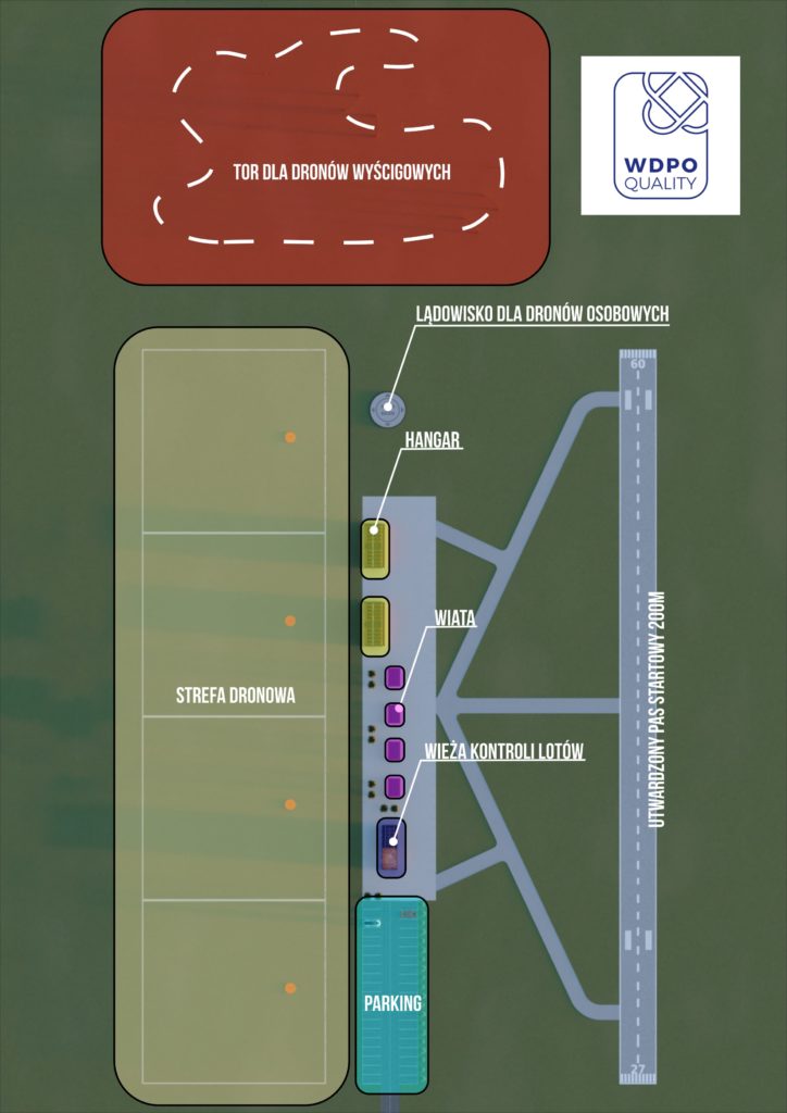
The minimum area of the site is 2.5 ha. The area is dry, level, without undulations and wetlands.
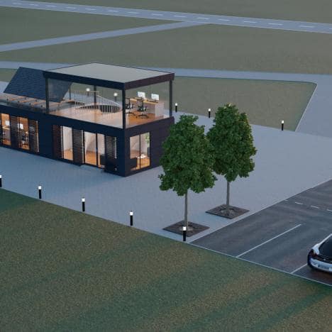
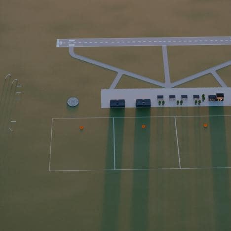
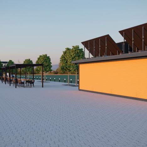
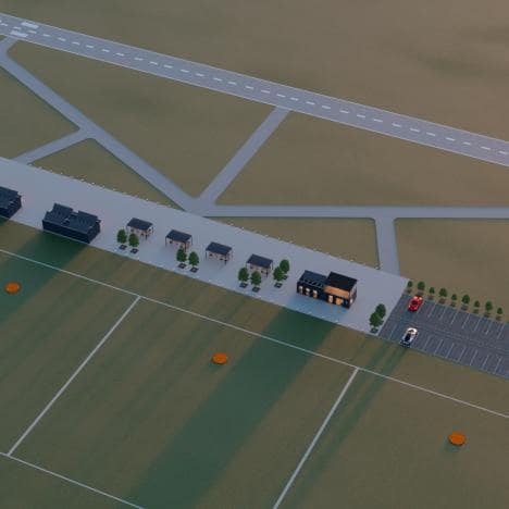
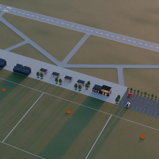
The airport should have the following zones:

  1. Airplane area with a runway, taxiways and a maneuvering area Lane length 200 m, width 7 m.
  2. Drone zone with 4 landing pads for drones. Drone zone with 4 landing pads for drones. The dimensions of the sector are 50 x 50 meters.
  3. A sports zone with a drone race track and a large landing pad for passenger drones.
  4. Parking for 40 cars.
  5. In the central part, there is a place where flights are organized
    1. WKL – Flight Control Tower consisting of 2 floors. The ground floor consists of 4 containers connected to each other, each 20ft long. The ground floor is divided into an office part (3 containers) and toilets (1 container). he second floor consists of two glass containers that will constitute the flight control base. Photovoltaic panels set up only on the first floor, no panels are planned on the roof of the second floor.
    2. H1 and H2 are hangars – Each hangar consists of 2 40ft containers connected to each other, with an opening long side (like a garage door).
    3. Photovoltaic panels on hangars.
    4. Additionally, 4 shelters with a table – a kind of paddock for teams working on drones – marked as P1, P2, P3, P4 in the drawing.

Technical parameters of the airport for drones

Airplanes area:

  1. Belt length not less than 200m. The strip in the direction from which the wind blows most often
  2. The width of the strip is not less than 7 meters
  3. There are no obstacles in the runway axis at a distance of 100m from each runway threshold
  4. No obstacles greater than 15m in height at a distance of 200m from each runway threshold
  5. Asphalt or concrete surface
  6. A maneuvering area that allows you to prepare an aircraft with dimensions of at least 10m x 20m for take-off
  7. Taxiways connecting the maneuvering yard with the runway in both directions

Multirotors with MTOW up to 50 kg area

  1. The touchdown sites for drones with a diameter of 3 meters are made of hardened material
  2. Maneuvering area for a drone with dimensions of 50×50 meters

Dronepad for drone with MTOW up to 500 kg

  1. Drone touchdown sites with a diameter of 10 meters made of concrete or asphalt.
The track for the drone sport is made in accordance with the assumptions of the drone league.

Crew check-in office:

  1. A minimum of 60m of office space with the possibility of arranging for lectures
  2. Access to high-speed internet
  3. Printer, scanner and computer
  4. Power sources

The stages of creating an investment:

  1. Location identification – obtaining the consent of the property owner
  2. Delineation of the area
  3. Design works – technical documentation
  4. Obtaining the necessary consents and permits
  5. Surveying works
  6. Earth and surface works
  7. Cubature works
  8. Renewable energy installations, water, sewage, waste, utilities.
  9. Final acceptance

Location properties:

  1. The airspace above the training ground safely separated from manned aviation – preferably outside the CTR.
  2. Access and agreed entry to a public road. Water supply network within the plot.
  3. Additional advantages:
    1. embankment – earth, mine or sand heap for the purpose of training in volume measurement,
    2. railway track for the purposes of training and research in the field of line infrastructure inventory,
    3. Wooded area for training and research on the calculation of the NDVI index of plants.
    4. Highway or expressway for road inventory and road safety training

Maintaining the appropriate parameters of the runway for airplanes – in particular, its length, width, surface condition and the absence of obstacles in the extension of the runway axis will allow for safe operations with unmanned aircraft. At present, most of these flights take place at aerodromes intended for manned aviation. Often, flight tests are associated with the need to stop air traffic, which is a significant inconvenience for everyone.